Summary: This hike is 6.6 miles with minor elevation gain, and many gorgeous views from a wide dog friendly trail. There is no fee to pay, and plenty of shade on a sunny day. It will make you want to explore the rest of the park, and those adjacent.
Pictures: (Once the slideshow is playing, click on it again to go to the Picasa album for higher quality pictures and more control.)
Details: You access this hike by Redwood Road from Oakland. I downloaded the PDF map from the park's website, and with a good navigator, it was easy to find the MacDonald Staging Area. We headed southeast on the MacDonald trail and took the Brittleleaf offshoot for a short one way hike to a great view. There are plenty of views from the trail, but the lookout at the end of Brittleleaf is a little special. There is a rocky outcrop there, and a bench. We retraced our steps back to MacDonald Trail, and continued to the end at Bort Meadow Staging Area. We then turned around and returned to the car. This makes a total of 6.6 miles. There is an extensive network of trails here. So, I know I will be back. I'm especially interested in hiking around Lake Chabot now that I have the brochure map in my hands.
How did I find this hike? I was looking for a dog friendly hike in the Bay Area, so I found this website that listed a few. I chose Anthony Chabot Regional Park, not just because it's first on the list, but because it is near the San Leandro Reservoir. Turns out this hike doesn't afford hoped for views of the reservoir, but it was rewarding in other ways. It's a great hike for vistas, and seeing other people with dogs. It's very accessible by road, and it isn't exactly getting away from it all. There are always homes within view on the parallel Skyline Drive. There are also quite a few Mountain Bikers, but the trail is wide and it wasn't a problem. The trail is partly shaded, so it was nice on a very sunny day.
Another reason I want to return is to try the hike recommended on the dog friendly trail guide. Apparently, we started at the wrong staging area. We wanted the Bort Meadow Staging Area, which I figured out after reading the hike description. There is a lot to see here, and it has the advantage of being close to home.
Monday, September 7, 2009
Saturday, September 5, 2009
Mitchell Canyon Nature Trail
 Summary: This is a hot hike in the Summer, but the Nature Trail is well shaded, and if you bring water you will be fine. There are signposted points of interest, and a guide available from the Visitor Center (and a wooden box at the trailhead) to educate yourself along the way. The trail is a wide fire road, and is easy until you get to the climb that starts after the Nature Trail, but we were tempted up the hill by the views and tolerable grade. It's 4 miles in and out, but you can make it longer.
Details: We were in the mood for a short hike in a new place, and it was cool in Vallejo. So, we dressed for cool. It's always a good idea to check the weather where you're going on the internet. I found it by searching Google for: "mount diablo hikes". That turned up a list of 7 popular Mt. Diablo hikes. We hit the trail head at 3pm, and it was a scorcher. Luckily, there is plenty of shade along the way from the Oaks that surround the trail/fire road.
Location: We partly chose this hike because we like going to Walnut Creek's beautiful downtown area either before or after our hike. This time we went to Pomegranate for a lunch out on the sidewalk. Actually, we often go there because the food is excellent, and so is the service. The hike begins at the end of Mitchell Canyon Rd. There are restrooms, water and a staffed visitor center where you can pick up maps, and advice. There is a $6 parking fee.
Pictures:
 The Nature Trail meanders right up the floor of the valley between two rocky ridges that afford beautiful rocky views.
 At the end of the Nature Trail, there isn't a sign, but you can tell when the fire road starts to switchback up the end of the canyon. If you do go up about halfway, you will be rewarded with beautiful views. This looks back toward the beginning of the trail.
 The pictures on the right gives you a good idea of how big the trail is. You don't have to worry about poison oak, unless you go off of the fire road. We did see a fair number of Mountain Bikers, and it looked like they were having a good time, at least on the downhill part. The trail is wide enough that there's plenty of room for everyone.

 Finally, some other vistas from the trail.
Sunday, August 23, 2009
Sunset Beach in Point Reyes in August

Summary: This is an amazing hike to the estuaries of Point Reyes National Seashore. We caught it on a cold foggy day, but it was hot at home. If you go, be prepared to find it cold. Only four miles in, and an easy hike. Very rewarding in views. It's great to see the changes in tide.
Pictures:
Once the slideshow is playing, click on it again to go to the Picasa album for higher quality pictures and more control.
Once the slideshow is playing, click on it again to go to the Picasa album for higher quality pictures and more control.
Sunday, July 26, 2009
Black Diamond Mines in Late July
 Summary: This East Bay hike is hot in July, but the mines provide natural air conditioning, and many of the trails are shaded in parts by Oak, Pine, and Manzanita. There is a lot of history here, and signs placed throughout the park to help you enjoy it. There is an intricate web of interesting trails to explore covering a variety of fascinating topography. Don't miss the cemetery, and take the time to read some of the touching inscriptions. You will have to hunt for them. Summary: This East Bay hike is hot in July, but the mines provide natural air conditioning, and many of the trails are shaded in parts by Oak, Pine, and Manzanita. There is a lot of history here, and signs placed throughout the park to help you enjoy it. There is an intricate web of interesting trails to explore covering a variety of fascinating topography. Don't miss the cemetery, and take the time to read some of the touching inscriptions. You will have to hunt for them. | ||||
| We chose Black Diamond Mines because it's only about 35 minutes from Vallejo, and though we've been once before, we wanted to go back because there is more than you can see in one visit. Much more. I first discovered this East Bay Regional Preserve using Google Maps. I just put it in Map mode and searched for my home town of Vallejo, then zoomed out far enough to see the green patches around us that represent parks. When I saw the large green patch south of Antioch I zoomed in and discovered Black Diamond Mines. There is a reasonable $5 fee, and a map is provided. | ||||
| ||||
From the cemetery we continued on the Nortonville Trail, then took a left on the Black Diamond Mine Trail. The rocky outcrops in the picture show the kind of views you will see. There are also spectacular views of the hills, and off into the distance to the north and you can see all the way to the bay. Then we took another left down the Manhatten Canyon Trail. We crossed the footbridge to the Chaparral Trail, then you guessed it, another left that led us to the Eureka Slope. | ||||
| This is a tunnel that bores down into the ground at a 45 degree angle. This is a cool spot to hang out. There is a wind blowing up out of the tunnel, and it is like standing in the open door of a refrigerator. On a hot day, this is just the thing. We then headed down the steps to the visitor center, which is closed until sometime in 2011 (when we hope it will reopen). The visitor center is down a mine shaft! You can stand in front of the gated entrance, and enjoy the cool breezes that blast out of the mine shaft opening. We enjoyed standing in the sun in the cool wind from the mine. It was air conditioning for the outdoors. | ||||
|


Sunday, June 14, 2009
Two Hour Hike at Henry Coe State Park
Summary: We had a great 4 mile loop hike at Henry Coe State Park. It is 13 miles east of Morgan Hill, and well worth the visit. Lots of trails for hikers and mountain bikers. Great vistas on the drive up, and vistas from the trail. Just check out the pictures.
 There is a very reasonable day use fee of $5. I'd pay more. We started at the park headquarters, and the rangers gave us great tips on how to get the most out of four hours we had before a social event in Morgan Hill. The advice we received was to take the Corral Trail to the Springs Trail for 2 miles. Then return on the Forest Trail on the other side of the ridge. This was a spectacular hike, mostly because the day was just so perfect. The day was supposed to be cold and cloudy, and we ended up having alternating heat and shade from clouds with cool breezes. It was actually perfect hiking weather. It would have been quite hot without the clouds. At this time of the year, it was quite dry. There was plenty of poison oak to watch out for, but it was not directly on or next to the trail.
 Along the Forest Trail there were a few Manzanita's and perhaps these are even Madrone's because this is quite a large tree. The sun was catching the peeling bark, and I was enjoying all of the colors in the tree's skin. The nice thing about this trail is that it is not especially wide, but it is flat and not rocky. There is not a lot of up and down. You're basically staying at the same elevation most of the time, so you're never winded. There are plenty of wildflowers to enjoy. Actually, the Forest Trail has about 27 items of interest numbered along the trail. You can take a trail guide and read about the numbered items of interest along the way. There are boxes at either end of the trail to pick up or drop off your trail guide. This is a nice way to educate yourself about the plants you see along the way.
 Here's a picture of me at the end of the hike. The park is quite large, with many more miles of trails to explore, and it was worth the two hour drive from Vallejo. We will definitely be back, especially since we can also visit our wonderful friends in Morgan Hill after the hike. If you have any questions about Henry Coe State Park, feel free to comment on the blog entry, and I'll get back to you with a reply comment. Also, I have numerous photos of this hike, and I will post them if asked via the blog's comments.
Saturday, May 2, 2009
Del Valle Regional Park Day Hike
Summary: This hike is just about an hour from our house in Vallejo, and five minutes from Livermore. There is a lake for boating, fishing, swimming with a beautiful recreation area for BBQ, fields for soccer, kite flying, and throwing the frisbee. Yet you can hike out of this along the full length of the lake, or up into the hills where we did where there are no crowds, and you may even see a bobcat like we did.
The Map:
View Del Valle Regional Park in a larger map
The Pictures:
The Story:
This was a discovery for us. We were headed to do a completely different hike, to Murietta falls, but when we got to the park, the ranger told us the area we wanted was closed. I would arrive earlier in the day to do the Ohlone Trail to Murietta Falls anyway. That hike is a 1700 ft climb and 6 miles each way. So, we left that for another day. We grabbed a map and set out for a wander.
The Map:
View Del Valle Regional Park in a larger map
The Pictures:
Click on the slideshow to play, once it's playing click on it again to go to the Picasa album for higher quality pictures and more control.
The Story:
This was a discovery for us. We were headed to do a completely different hike, to Murietta falls, but when we got to the park, the ranger told us the area we wanted was closed. I would arrive earlier in the day to do the Ohlone Trail to Murietta Falls anyway. That hike is a 1700 ft climb and 6 miles each way. So, we left that for another day. We grabbed a map and set out for a wander.
Check out the Del Valle Regional Park website for all the basic info. It was $6 to get in, and the map is included. You can stay close to the car, and have tons of fun, or you can hike or canoe into a lakeside campsite. This is one fun place.
We hiked along the lakefront where picnickers, fisherman, and kids playing swarm. It is very multicultural, and great people watching. We hiked past the last parking lot, and you can hike the entire length of the lake. At the point where the trail turns uphill to get around Badger Cove, we turned around, and decided to make our way back in the hills to get some views. I'm so glad we did that. For one thing, this gives you incredible views, but we also left people behind us for the most part. We encountered only one other couple, and after them, we saw a bobcat.
We saw him at Hidden Canyon, and he was just walking up the trail towards us. We stopped, and he continued to walk torwards us a little bit, then he cut off the 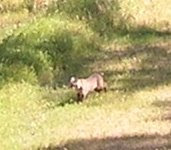 trail. There is one picture where he can faintly be made out in the trail, but my camera is better on big scenes than on zooming in on moving wildlife. This is only the second time that I've seen a bobcat on my hikes, and it was a real thrill. He looked like a really muscular big housecat, but he had the bob tail, and the tufted ears with black tips. I've done some research since, and to me he looked more like a Canadian Lynx, which are threatened in the lower 48, but I don't know if that's possible. Here's the blurry pick. Decide for yourself.
 trail. There is one picture where he can faintly be made out in the trail, but my camera is better on big scenes than on zooming in on moving wildlife. This is only the second time that I've seen a bobcat on my hikes, and it was a real thrill. He looked like a really muscular big housecat, but he had the bob tail, and the tufted ears with black tips. I've done some research since, and to me he looked more like a Canadian Lynx, which are threatened in the lower 48, but I don't know if that's possible. Here's the blurry pick. Decide for yourself.
 We'll definitely be back to Del Valle Regional Park for kayaking, and more hiking.
Sunday, March 29, 2009
Sugarloaf Ridge State Park - Godspeed Trail
Summary: This is a beautiful hike to do in the Spring due to the wildflowers in bloom, and the amazing views. The elevation gain is moderate, but challenging. There are lots of nice people on this trail. You may see Turkeys. You will see lizards, ravens, and turkey vultures.
(To read my comments, click on the slideshow, and browse at your leisure.)
What a great day in Sugarloaf Ridge State Park. You can do this hike without paying the day use fee. The parking is on the left side of the road before you enter the paid use area.
Be sure to take water with you. The hike crosses streams that were flowing in late March 2009, but they may be dry by Summer. We will have to go back in Summer and start it early in the day, or late in the afternoon. It was hot on a nice Spring day, so it will bake in Summer. We heard turkey's calling, but didn't see them this time. Last time we did this hike we say their footprints in the mud. They are distinctive three toed prints, and surprisingly large. Kevin spotted a tiny little ringneck snake on the trail, and we saw many varieties of lizard. The wildflowers were in bloom, and they were very nice. You have to see them in the Spring!
Also, don't miss Gunsight Rock, where the real views are. Mount Hood doesn't have big views, but it is not far from the junction where you can turn off to see Gunsight Rock.
Friday, January 30, 2009
Jack London State Park
Summary: This is a place to explore, to linger and to savor. Yet you can walk for miles and miles. There is much to see, and vistas at the summit that will thrill you. This is a place with a history, and if you explore the stories of this place, you will know the tragedy of Jack London's life. There are picnic tables, barbeques, and water available.
Pictures from the hike: (click slideshow to see bigger and with captions)
Jack London State Park is just a mile west from Old Glen Ellen. There is a $6 fee per car to enter the park which closes the gates at 5pm. You'll want to have time so get there early enough to cover the ground you plan to hike. The trail map is part of the brochure available at the previously linked site.
Your first time to this park, you'll want to explore slowly the ruins and read the plaques. Jack London is the author of Call of the Wild and White Fang, both favorites of mine. In one direction you'll find Jack London's grave and Wolf House. In the other direction you'll find the ruined winery, the cottage, the silos, the pig palace, and further afield London Lake, and even further Sonoma Mountain.
Subscribe to:
Posts (Atom)
